
On visits to Los Angeles and Las Vegas, Numerama had the opportunity to compare different map applications. Apple’s efforts paid off. In cities where Apple Maps is extensive, the iPhone software is best.
Mocked at their launch in 2012, Apple Plans (or Apple Maps in the original version) are still hotly contested in 2023. The fault of maps that were too imprecise at first, as well as a presentation that was undoubtedly more confused than with the competition (Google Maps, Waze…). Even today, many iPhone owners swear by Google Maps as the only viable option for getting around.
Since 2015, however, Apple has increased its efforts to make its service better. After months of touring France, the Californian brand rolled out its internal maps in France in July 2022. This has greatly improved the quality of information provided by Apple Maps, which no longer has much to envy the competition in terms of the reliability of routes shown. But changing user habits will take time.
Logically, the US took a bit of the lead. Already in 2018 in California (and in January 2020 in the rest of the country), Apple began testing its new Apple Maps. The result is striking. In Los Angeles and Las Vegas, the two cities Numerama visited for CES 2023, Apple Maps is without a doubt the best map app we’ve tried.
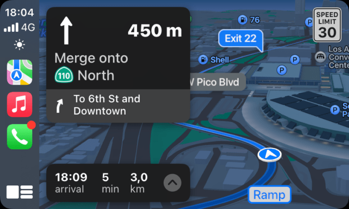
The 3D interface in Apple Maps is sublime
France may have had the new Apple plans since July 2022, but it does not yet have all the features of the service. For some reason beyond us, Apple has decided not to offer the same options in all countries. The implementation of the new Apple plans occurs in several phases, 12 to be exact, according to the website of Justin O’Beirne. The blogger who has made Apple Maps his specialty (his articles on city mapping are fascinating), Paris currently only has access to 8 new features out of 12. A city like Los Angeles, where the implementation is complete, therefore has advantages over France :
- Several important buildings, such as the airport or shopping malls, are modeled from the inside. We can therefore obtain navigation information, including augmented reality, to find a store.
- Public transport timetables are updated in real time, these are estimates based on the usual data in France.
- Routes for bicycles are available. In France, you must use Google Maps or special applications, such as GeoVelo.
- The city is modeled in 3D, which is probably the most important point.
3D city modeling is what makes Apple Maps so great in the US. There are hundreds of buildings, including hotels and parks, visible in 3D and color. In addition to surprising the user as soon as he searches for a destination, this feature greatly improves the quality of navigation. Where Google Maps and Waze settle for rectangular buildings, Apple gives the impression of being in a video game.
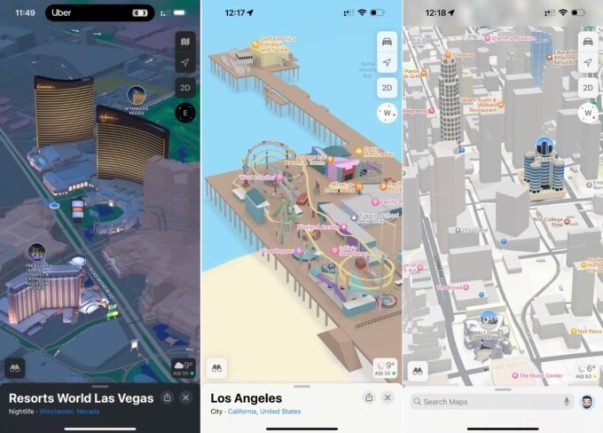
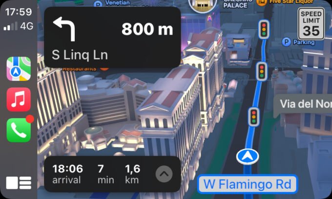
In Las Vegas, where everything is colorful and bright, it is even more impressive. Apple Maps doesn’t feel like a map app, but a 3D recreation of a city. These colored buildings also appear when in navigation mode, making it much easier to follow a map. What is shown to the right of the screen is actually what is to the right of the car.
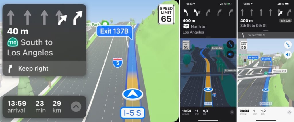
Apple Maps’ 3D display has another purpose: to prevent you from taking the wrong exit on the highway. In the country where it is easy to find 7 to 8 lanes on the same axis, Apple Maps is the only software with a sufficiently clear interface to avoid mistakes. When Google and Waze tell you to stay in the 3rd or 4th lane, Apple draws on the map which lanes you should take. Once the exit is close, an animation allows you to anticipate the shape the road will take to anticipate its braking. Once you understand the concept, it’s impossible to go wrong. Apple’s map, still colorful, is extremely clear.
Even on foot, navigation is more pleasant with Apple than with Google. On a hike to the Hollywood sign, only the Apple app gave us clear enough information to climb without taking the wrong route. Google suggested going through an inaccessible gate on foot. In Las Vegas, escalator directions, often required to get from place to place, have always been perfect on Apple Maps.
Finally good indications
Being pretty is one thing, providing correct information is another. How can one not bear in mind the mistakes of the first Apple plans, which took its users too often in the wrong place? If our passage on the American west coast was short, we never had the slightest problem with Apple’s software. On the contrary, he was often the only one who provided factual information about the building’s opening hours (Google once got the hour wrong).
How to explain the victory of the Apple Plan in the United States? We can imagine two reasons:
- In the US, specifically in California, Apple plays at home. Its effort is therefore greater, while Google is perhaps too well-established and focused on more global deployments.
- In the US, more than 50% of the population has an iPhone. For merchants, it is more important to provide Apple Plans with correct information than in France. This will undoubtedly help Apple improve its service.
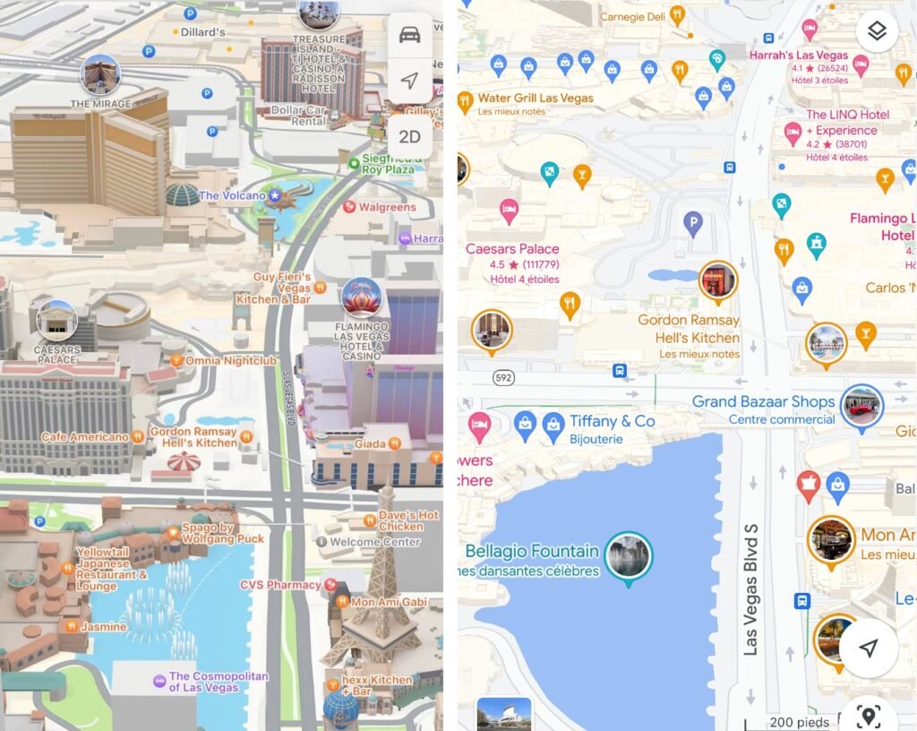
Will Apple eventually have the best mapping software on the planet? Allow us to doubt it. Already because the implementation of the new Apple plans is slow and carried out in several phases. So because Google does not stand still. The presentation of a 3D Google Maps worthy of a video game had impressed in 2022. The rollout of such a feature, undoubtedly worldwide in one fell swoop, could allow Google to overtake Apple very easily. Among other things in the USA.
Build the future of Numerama with us by answering these questions!
After reading your article, it reminded me of some things about gate io that I studied before. The content is similar to yours, but your thinking is very special, which gave me a different idea. Thank you. But I still have some questions I want to ask you, I will always pay attention. Thanks.